")
")
Przedstawiamy Państwu najnowsze informacje o projekcie terminalu LNG z zakresu bezpieczeństwa nawigacji.
Badania oraz wdrożenia w tym zakresie prowadzone są w Polsce przez zespół IRM kierowany przez prof. Stanisława Gucma
Wizualizacja Portu Zewnętrznego w Świnoujściu z Terminalem LNG
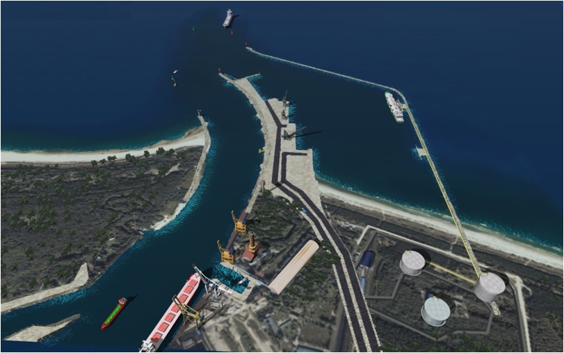
1. Introduction
The herein presented method of the optimization of the layout and parameters of ports has been specifically worked out by this author to define the dimensions the outer harbour in Świnoujście, where an LNG discharge terminal is being planned. The newly-developed method consists in the following steps:
- analysis of actual variants of the location of the harbour by using selected criteria for the comparison of the variants. The analysis allows for the choice of the best location variant;
- optimization of the harbour parameters (the best location variant) with the use of purpose-made three-stage simulation method of optimization.
The port of Świnoujście is situated in the northern part of Świna Strait. Belonging to the Odra Estuary, it is a complex area in terms of hydrological network and prevailing hydrodynamic phenomena. The estuary consists of a branched stretch of the lower Odra River, Zalew Szczeciński (Lake Szczecin); three straits: Dziwna, Świna, Piana and part of Pomorska Bay (adjacent to the straits mouths). Flows of water in Świna Strait depend on changes in the state of water in Pomorska Bay and Zalew Szczecinski and on wind impact. Generally, water flows are unsettled and generate ingoing and outgoing currents moving at a speed of up to three knots.
The existing spatial arrangements in the port of Świnoujście and its location at the mouth of the Świna imposes certain restrictions on engineering work that aims at extending or deepening the Świna’s mouth. Such actions would increase flow intensity and current speed, consequently the natural environment of the Odra Estuary would undergo degradation.
One limitation of the commercial port at Świnoujście is the location of its cargo handling quays along the fairway leading to the port of Szczecin. Traffic intensity on the fairway amounts to about 10,000 ships a year. Taking the above conditions of the port into account, its maximum parameters are identified as follows:
– maximum parameters of ships safely manoeuvring in the port of Świnoujście (bulk carriers) amount to:
- length 270 m,
- draft 13.2 m;
– maximum parameters of ships that will be handled at Świnoujście Ferry Terminal are these:
- length 230 m,
- draft 10.0 m;
– due to the traffic along the fairway and strong currents the location of terminals handling dangerous goods (such as LNG, LPG, fuels etc.) is risky;
– due to strong currents there is no possibility for a location of shelter area for ships.
With the above restrictions, the following goal can be defined for the construction of an outer harbour in Świnoujście:
- cargo handling of ships with a length to 300m and draft up to 13.5m,
- handling of new types of cargo,
- dangerous cargo (LNG)
- other cargo (Ro-Ro, Ro-Pax, bulk cargo)
- increase of cargo handling potential at the port of Świnoujście to 20 million tons in 2020,
- enhancement of navigational and environmental safety in the area of southern Baltic by locating a place of shelter in the outer harbour.
The outer harbour in Świnoujście is intended for serving ships with 300m length and 13.5m at the maximum. Ship’s size and manoeuvring characteristics strictly affect the safety of navigation. The two parameters determine the ”maximum size ship”, defined as the largest ship that at assumed navigational conditions can safely manoeuvre (perform a certain manoeuvre) in an examined area. The term maximum size ship, in fact, is applied to a ship whose one of the parameters has the maximum value [Gucma S., 01].
Taking into consideration real characteristics of ships concerned, the parameters of a “maximum size ship” can be identified for each type, including:
- LNG carrier LC = 300 m T = 12.5 m;
- RO-PAX LC = 300 m T = 10.0 m;
- RO-RO LC = 300 m T = 13.5 m;
- bulker LC = 300 m T = 13.5 m (lightened).
Of the ships considered, only LNG carriers transport hazardous cargo. Therefore, requirements for the safety of manoeuvring and berthing for these ships are higher than for the other types. Stricter safety requirements make an LNG carrier a „characteristic ship”, for which the research aimed at the optimization of the outer harbour in Świnoujście. Therefore, designed operational conditions of Świnoujście’s outer harbour can be defined as follows:
- The maximum ship entering the outer harbour is an LNG carrier with a cargo capacity of 200.000 m3 (at present the largest ship of this type in the world).
- The maximum wind speed, at which the maximum size gas carrier can enter the port is Vw = 12.5 m/s (any wind direction).
- Wind speed and direction during LNG carrier berthing along the discharging terminal – no restrictions.
- Four tugs are needed during all kinds of manoeuvring – entering, leaving, turning and berthing (two tugs with minimum pull force 45 tons and two tugs with the pull of 30 tons).
- The pilot on board a gas carrier entering the port is to be equipped with the pilot navigational system and the docking system.
Taking into consideration the operational conditions, the outer harbour has to ensure that:
- manoeuvres of entering, leaving, turning and berthing are safe in the assumed conditions;
- ship’s stay and cargo discharge along the berth are safe.